 |
 |
 |
Loading...
| Search Result for "20279" | ||||
| Lot | Description | Status | ||
20279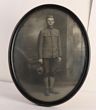 Click to enlarge photo | USA. Army. WWI US 'Doughboy' soldier full length portrait in oval frame with domed glazing. Round collar discs to collar, holding the USA style felt hat, wearing gaiters. Not pulled apart, to search for names. Size approx 375x300mm. Tiny closed split at top of frame o/w VGC. Great photo. | AVAILABLE at A$100 | ||
|---|---|---|---|---|